 Campervanning
in Europe.
Campervanning
in Europe. Part 5 France
again and Switzerland 
Switzerland
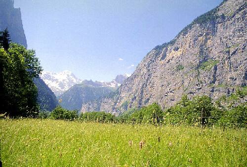
The Three Passes Drive
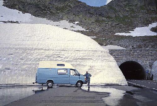
Susten Pass SONPS
We crossed back into France with no formality beyond a friendly wave from
the Gendarme on the border crossing between LES and FOS, and
proceeded along the DD618 toward ST GIRONS.
Many French roads are very narrow, and really inadequate, which explains the
widespread network of toll roads. Along the narrow D618 we had a minor encounter
with another large campervan going the other way, and failing to slow down
enough. Our left hand side mirrors hit, smashing ours. We had slowed considerably,
but the other van did not. Fortunately we found very few instances of careless
driving such as this and no major damage was done. The other van failed to
stop, although he must have heard the impact.
Route map Spanish-French border - St Giron [48 Kb]
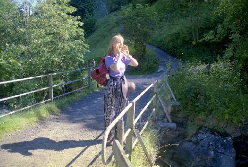
We found a small parking area along the D618 where we parked for the night.
It is a very quiet road at night and being only 10 meters off the road was
no problem. ![]() SONP
SONP
7/6/2000 The steep and winding D618 over the COL DE PORTET DASPET (1069M) passes through extremely pleasant almost sub tropical greenery, with a number of SONPs and access points to rivers for fishing. Along the D117 from ST GIRON to FOIX there are more SONPS and parking areas to picnic, and to stop and fix the starter motor relay!
We encountered our first mechanical problem, all of a sudden the van would not start, at a place we had stopped to admire the view. After a few checks I thought the starter solenoid was the problem, and only after removing and disassembling it did I find that the simple problem was that a spring washer had burned away, when the main starter lead connection had become a little loose, resulting in arcing on starting the engine. Reassembling and tightening the connection fixed the problem, minus the offending washer. It took about two hours to fix, probably quicker than calling the French Auto Club, and it proved the worth of my very basic tool kit, of a few spanners and screw drivers, bought in a London "Pound Shop". £2.50 for a set of six spanners and £1 for a set of cheap screw drivers, rubbish quality, but I only bought them in case they would help in some minor emergency, and they proved their worth.
Route map St Giron - Foix - Carcassonne - Nimes. [ 103 Kb]
In FOIX a pleasant town of manageable size, with a picturesque tri-towered Chateaux, we found a Ford dealer and after a minor misunderstanding when they thought we wanted them to fix our broken mirror, rather than just sell us the part so we could fix it ourselves in five minutes, we got what we needed. The staff were ever so pleasant and helpful, and between my very few words of very bad French and their equally few words of probably much better English, we soon had the parts needed to fix the mirror, and they even invited me to do it in their car park.
I have read on the Internet a lot of what I found to be arrant nonsense about how arrogant and unhelpful the French can be, we never found that at all. I think people tend to forget, when you are in a foreign country, you are the ignoramus that cant speak the lingo, the local customs are the ones to be observed, and you need to adapt to their ways. In shops, supermarkets, service stations, the police and Gendarmes, all we ever encountered was helpful courteous people, only too willing to assist us in whatever minor thing we wanted.
WE found an LIDL supermarket in FOIX next to the Ford dealers, and found that it provided some of the best value to be had. Goods imported from other EU countries and elsewhere in the world at prices much lower than in the regular supermarkets.
Along the D119 towards CARCASSONNE we found plenty of parking areas,
some near the river in FOIX. At 11Kms west of CARASSONNE we camped
in one overnight. ![]() Along the D119 there is an excellent picnic area in the village of CASTELNAU
DURBAN, which is not marked on the AA map, and although it is signed no
camping, "parking city style" would probably be OK, particularly for a single
night stop.
Along the D119 there is an excellent picnic area in the village of CASTELNAU
DURBAN, which is not marked on the AA map, and although it is signed no
camping, "parking city style" would probably be OK, particularly for a single
night stop.
8/6/2000 We followed N113 east towards NARBONNE and then the N9/N113 to BÉZIERS and the N112 toward SÈTE on the shores of the GOLFE DE LION. We diverted into a new resort development near VIRAS PLAGE, a beautifully landscaped maze of flats and roundabouts, complete with a nudist section, divided off by security gates. Clearly it was according to the map, by the sea, but after half an hour of driving in circles round the roundabouts, between the flats and along the beautifully landscaped streets, we failed to find the sea, silly us!
The concrete coast has in spots become so dense that the mighty sea has itself been lost! Returning to the road to SÈTE we came again upon the lost sea. Passing perilously close to the sea now, the road being built on the dunes, we came to a relatively unspoiled area of coastline, un-besmirched by concrete and high rise. a few kilometres west of Sète. The road was lined with campervans, literally hundreds of them, obviously set up for at least overnight, if not much longer stays. The wide and pleasant white sandy beach was obviously a great attraction, and best of all it was free, a rare thing in Europe. We stopped to walk on the beach and at least paddle in the waters of the Mediterranean. Hundreds were obviously making this their holiday, but with not a tree for shade, and having to park beside a busy road, this was not a place we wanted to stay, although you could obviously use it as a SONPS, as so many do.
East of SÈTE begins a vile and expansive conurbation extending to beyond NIMES, a seedy French version of Australia's Gold Coast, a place to be avoided by travelling inland (as in the Australian case too). The lesson, practically all of the coastal areas of Europe are hideous concrete jungles, if you are an Australian, and this is not your one big chance in life for a tan, skin cancer, and a swim in the sea, give them all a big miss. The French seaside is only appealing to those who know nothing better, concrete jungles be dammed.
Route map Nimes - Gap [107 Kb]
We headed NW along the N86 toward REMOULIMS. There are no SONPS after the beach side area near Sète until where the N86 crosses the A9 toll way, just north of the overpass. This is where we stopped, on some open waste ground, but it is not a good SONPS as the A9 is extremely busy and noisy all night and even being some 100 meters away, noise remains intrusive.
Had we then known, we would have pressed on to REMOULIMS where there
is an official FREE campervan parking lot on
the north side of the river GUARD immediately after crossing the historic
bridge. Just suitable for overnight parking. There are no facilities provided,
but it is much quieter than near the A9. ![]()
9/6/2000 Along the N86 from Remoulims to PONT ST ESPRIT there are plenty of SONPs and the latter town also caters for campers. We took the D94 to NYONS, a large town with good supermarkets and discount fuel. In France you need to shop around for fuel, and the best prices are usually to be had at the large supermarkets which often have fuel retailing facilities attached. The D94 route is very popular with campervans, with a lot of Swiss and Germans using it as a route into southern France and on in to Spain. We followed D94 heading towards GAP along the RIVER EYUGES where there are plenty of picnic spots and SONPs with tables and shade. Beyond NYONS to SERRES in particular there are plenty of points of access to the river which is shallow and flows over rocks where the waters become warmed and very good for a bath.
We spent the night at a riverside SONPS on D994 just north of SERRES and four other campervans and a bicycle tourist joined us. The town even provided toilets at the site, with toilet paper supplied. Apart from the rarity of public toilets in France, or Spain and the UK for that matter, toilet paper was not even provided in any of the campsites in Spain or France where we have stayed and paid for the privilege. So Serres really has its act together.
Route map Gap - Albertville [83 Kb]
10/6/2000 Proceeding along D994 through GAP and past VEYNES, we had intended to take D937 north to CORPS but roads have apparently been renumbered in the area and the through destinations are not posted, so we could not find the road and continued on to GAP, a large town with many supermarkets for resupplies.
N85 "Napoleon's Route", north of GAP is very steep at first, 1st a and 2nd gear in places, but is very scenic and soon levels out to follow a river, popular for canoe and kayak events, and with a number of parking spots and SONPS along the road. We stopped overnight in one and were soon joined by another campervan from Switzerland.
11/6/2000 As it was very cloudy we decided not to travel very far, for we did not want to miss the wonderful alpine scenery. Following the N55 towards LA MURE we turned on to D526 to LE BOURG DOISANS, over the 1367 metre COL DE ORNON through tiny villages, France at its most rural and most remote, beside glacial rivers of greenish blue waters coming straight from the melting snows of the Alps. Several good SONPS noted along the way. Spectacular rock strata can be seen at Le Bourg DOisans.
We then joined C91 and headed to VIZILLE and GRENOBLE. Along the road there are several interesting monuments to French resistance fighters of WW2.
There are numerous access points to the rivers along these routes and small parking spots. The area is very popular with campervanners and finding SONPS is not at all difficult, we parked for the night by a track leading off the D91 toward the river a few hundred meters east of the bridge where D91 crosses the river about 6-8 Kms east of VIZILLE.
12/6/2000 Again it was heavily overcast so we travelled slowly towards GRENOBLE and took the D532 toward ALBERTVILLE. The D532 follows several rivers and there is access for fishing and some good SONPS. At LA ROCHETTE there is a private pay to fish lake, with a public roadside parking place which actually has a public toilet. It makes a pleasant place to stop for lunch and have a walk around the lake, and would also be a fine SONPS. D523 -D525-D925 is a pleasant drive through small towns, fairly flat and straight following a large valley along. We much preferred it to the motorway (toll road) or the larger N90 road to the north, which also lead toward ALBERTVILLE with varying degrees of haste.
The municipal campground at ALBERTVILLE charges 37FF for two and camper, without electricity. It has good facilities, grassed and shaded sites, and is one of the best campsites we have so far encountered. French Municipal campsites are probably the best value camps in all of western Europe. Albertville is Highly commended. It is close to the very pleasant town of manageable size, site of a previous winter Olympics, which has several large supermarkets. Although we only stopped overnight, as the weather improved next day and we were excited not to miss the opportunity of good views as we crossed into Switzerland, one could easily spend a few days in this pleasant and good value campsite.
Before heading in to Switzerland it is important to fully restock your van with as much as you can carry in the way of non perishable food, preferably enough to see you all through Switzerland, because you will pay a LOT more for things there. Also take as much meat and fresh fruit and vegetables as will keep in your fridge. Fresh perishable food is the only thing you will then need to buy in Switzerland, apart from any special local delicacies or souvenirs that take your fancy.
Route map Albertville - Martingay - Sion Switzerland [47 Kb]
13/6/2000 With improved visibility we decided to press on into Switzerland, following N212 to ST GERVAIS LES BAINS and N205 to CHAMONIX, and although Mont Blanc was partly obscured by mists , we were able to get some glimpses of the spectacular Alps. N506 to the Swiss border is narrow and in poor condition, notably worse than most of the generally second rate French minor road network, but it is not difficult or too steep over the pass. Border formalities were minimal, just had to show our passports, and immediately in Switzerland the road to MARTINGAY improved vastly.
![]()
Switzerland
If you want to use the major roads in Switzerland you have to buy a tollway pass which entitles you to use any tollway for a set period of time. Periods of a week to a year can be bought. The passes are not compulsory, as you can travel anywhere in the country on the excellent secondary and minor road network for free. However travelling will take you longer as you may have to climb passes instead of going through tunnels, and hence get to see more of the country. We never used the tollways and recommend this approach. The Swiss free roads are excellent and unless you are in a real hurry, in which case you shouldn't be doing a campervan tour, you dont need the tollways.Route map border to Gletsch [53 Kb]
The road (No 9) from MARTINGAY to SION is excellent, slowing
only where it passes through villages. This section of the route is straight
and flat along a wide valley, and not very exciting scenically. There are
less stopping places of quality than we like, but we eventually found a good
SONPS on a forest track leading off a signed "P" parking area on road "9"
just west of SIERRE. By driving about 100 meters along the track which
serves as access to maintain a power line, we were totally screened from the
road. ![]()
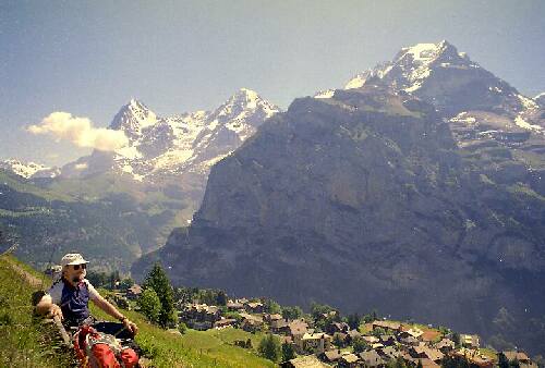
The Three Passes Drive.
Route map The Three Passes Drive [33 KB]
14/06/2000 Proceeding on through BRIG and GLETSCH we ascended the GRIMSEL PASS, part of the spectacular three passes circuit. This drive provides views of the finest alpine scenery enabling you to access altitudes in your campervan that you need to take the very expensive tourist trains and cable cars to in the area around INTERLARKEN.
The GRIMSEL is the most trafficked, most touristy and most developed of the tree passes, but is not in my opinion the most scenic. As the day was fine we turned around at the top of the Grimsel Pass, in order to be able to take the long way round, via the FURKA PASS to ANDERMATT and WASSEN thence through the, SUSTEN PASS to AARESCHLUCHT to end the day in INTERLARKEN.
All of the passes offer excellent scenic driving and views of the Alps, but in our opinion the FURKA and SUSTEN PASSES are the most scenic, and are not blighted by the ugly commercial developments which scar the GRIMSEL, including a shop obscuring the ROHN GLACIA and actually charging 5SF to pass through its premises onto the glacier for walks. There are also numerous ugly hotels and shops at the top of the GRIMSEL PASS and a pathetic mini Zoo!
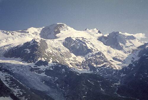
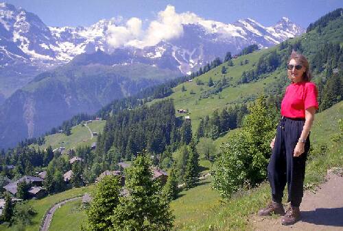
View from the road in the Susten Pass.
The best glacial scenery by far is to be found along the SUSTEN PASS, where
the glaciers are more numerous, bigger and more picturesque than the ROHN
GLACIER in the Grimsel Pass.
The roads over all the passes are generally excellent and are being improved
(June 2000) on the few remaining rough sections of narrow old road. None presented
any difficulty to our Ford Transit, but there is a 2.5 metre width restriction.
The secondary road network in Switzerland is vastly superior to that of France,
and we have not needed to use the tollways at all.
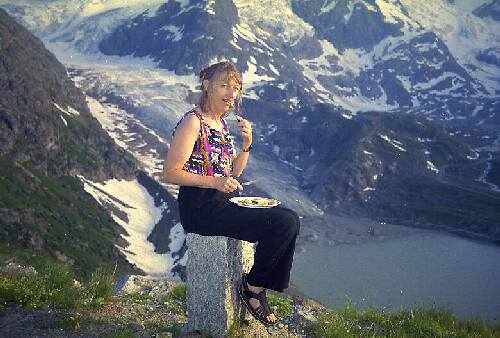
Sharon enjoys dinner and the view from our van at the SONPS
where we parked overnight in the Susten Pass, overlooking the Steinlimmi Glacier.
There are numerous viewing points (usually not signed) in all of the passes
and some are large enough for overnight parking, and no restrictions are posted.
At the top of the Susten Pass.
The three passes drive is one of the gems of a campervan tour of Europe, an absolute MUST not be missed.
Route map Aareschlucht - Interlaken area [54 Kb]
The road from AARESCHLUCHT to INTERLARKEN passes along the shores of a large lake, and here signs indicate no parking between 2200 and 0700 hours, in some places, obviously directed at stopping overnight parking by campervans. So if you want a SONPS pick a spot in the alpine passes where there are no restrictions. However in winter this would not be feasible.
We camped in INTERLARKEN 23.80 SF for two and camper, no electric, a pleasant site beside the river, close to town but with mediocre facilities. Other parks further from town were just as expensive so it pays to check out a couple, if you have time, to get the most convenient and best value.
The only thing cheaper than in France is "Swiss Army" pocket knives, the top of the line model Victronix with everything is 69.00SF, and there are numerous models from around 9.00SF which represent good value, and actually are cheaper than elsewhere in Europe or the UK.
Our prudence in FULLY stocking the van proved to be well founded. You should even buy UHT long life milk, orange juice, soups and vino in France, or in Italy, Austria or Germany, where ever you come from, it will be much cheaper. All alcohol is much dearer in Switzerland.
Meat is most notably far more expensive in Switzerland, so also have the refrigerator stocked, and buy some cans of fish and meat to last your visit.
Dining out is also very expensive with main courses typically 20-30SF, so a very modest restaurant meal for two people would easily cost 100SF, compared to commonly available "menus" in France for around 60-80FF, or about 30-40SF for two. So dine out in France, and cook in the van in Switzerland, using your imported French bought ingredients.
15/06/2000 We spent the day in Interlarken, which is purely a tourist town, and gateway to the most touristy developed section of the Alps. A very pleasant town, and well worth exploring and window shopping, and about the best place to buy any Swiss souvenirs, as there are lots of shops and competition keeps souvenir prices as low as anywhere in Switzerland. A good place for an overnight stop, but we feel that with a campervan you would be better off spending the bulk of your time in the area camping in one of the parks further up into the mountain valleys, closer to the scenic attractions and walks.
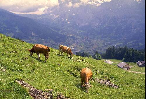
16/06/2000 We drove up into the higher valleys to GRINDELWALD,
also a pleasant tourist town, but very short on parking, and the "parkhaus"
is too low for campers. Roads extend in several (dead end) directions, but
they are not publicised, so by exploring, you can get well up into the mountains
for walks, without using the expensive tourist transport.
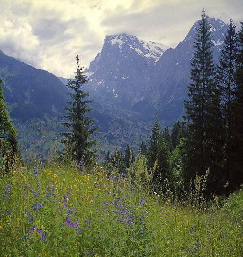
Wildflowers abound in the alpine meadows above Grindelwald.
You can drive part way up to HOLENSTEIN, or take the GRINDELWALD BUS up even further, as the roads are posted as "no entry to cars" beyond a certain point. This obviously does not apply to the many locals who live on small farms well above this point. If you had a car you could blend in and drive all the way up, as the roads are very quiet. We parked the camper in a small roadside parking area and hiked up to HOLENSTEIN (1624M elevation) the middle station on the cable car up to MANNLICHEN. It has no other function, and is not in itself a particularly glorious destination, although the walk up is absolutely delightful, passing through fields of summer Alpine wildflowers, and you get good views over GRINDELWALD and of the Alps from GROSS SCHEIDEGG to THE EIGER.
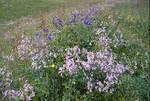
The track up to Holenstein passes through fields of wildflowers in season.
The walking track, partly on roads, although well signed, is very poorly
maintained in many places and is steep, it requires good walking boots. The
track passes through fields with cattle and goats grazing, each wearing a
bell, with its own distinctive tone, so the hills really are alive with the
sound of music, a continuous tinkling of the Grindelwald Bovine Symphonica!.
The times posted for walks may be right for Swiss mountain goats, but if you
are not a mountain goat, or an extremely fit Swiss hiker, allow considerably
more time than they say! By driving part way up you can avoid using the overpriced
cable cars, although some walkers take a one way ticket from GRINDELWALD to
HOLENSTEIN and walk down. However it is so steep that hiking down is almost
as hard as hiking up. While there are certainly good views, there is nothing
better than scenery in the three passes drive, where you can drive to 2400M
elevation, in the SUSTEN / FURKA PASSES, and hike at higher altitudes, including
on glaciers, from your camper van, park over night for free with no hassles,
and not have to use the expensive tourist transport, like the cable cars or
trains to get to your point of departure.
The Holenstein Bovine Symphonica. The hills are are alive
with the sound of music, hundreds of cow bells combine into a tinkling symphony.
Another road from GRINDELWALD goes to the OBER GRINDELWALD GLETSCHER
(Glacier) where there is a pay and display parking area, which charges 3SF
for 6 hours, and they post fees for 12 and 24 hours, and up to 7 days, but
also say "no camping". So if you just "park" there, "city style", which means
giving no external appearance of camping, no awnings extended, no chairs outside
the van, no BBQs and dont drop too much grey water, you would probably be
OK. If anyone complains, show them you have paid for 12 or 24 hours parking
and politely tell them you are simply parked for a rest between several long
walks, that you are NOT camped, and to please go away! You can walk from the
car park to a number of points, and the parking fee scale extends up to 7
days for 35SF. There are also several campgrounds in this area.
Well every one Yodels in Switzerland, don't they?
We drove back down the valley to the main road junction and up another main valley to GRIMMELWALD, past TRUMMELBACH FALLS. In this valley there are also several campgrounds and we stayed in one at STECHELBURG. 20.20SF for two and camper no electric. A nice location beside the river, a few level sites, but slopes are small, charges 1SF coin in slot for showers. Good views of the Alps from your campsite.
17/06/2000 We took the cable car to MURREN, 29.20SF return
for a ten minute ride each way, exorbitant cost. The views from MURREN are
excellent, and we walked the "Panoramaweg" However they are no better than
can be had from several points on the three passes drive in the SUSTEN / FURKA
Passes in particular, where you are much higher than Murren. If you want to
spend a lot of time in this area a weekly cable car pass SF133 may be worthwhile.
You can get all the brochures from the INTERLARKEN tourist office, before
you come. They have a web site.
The main street in Murren. Delightful place yes. Untouched
village No.
The area is such that from the valley floor the views are "comparatively" modest, although the alpine scenery is so glorious that even "comparatively modest" is still spectacular to a first time visitor. So you have to use the very expensive tourist transport to the higher levels, or walk up to the real starting points around MURREN.
On the Panoramaweg above Murren.
All the tourist advertising hype directs tourists into the INTERLARKEN area and one of the two valleys (which operate separate cable car and train systems, so you can't use one weekly pass to see both!) and to around the Yungfrow, Eiger and Monch peaks. It is certainly a beautiful area, not to be missed, but these are not the highest mountains in Switzerland, let alone being the top of Europe" as the tourist hype claims. Equally good views, higher mountains, and walks starting from a range of altitudes up to 2400M can be accessed for free from your campervan by driving over the various passes. So budget your time to spend some of it in other part of the Alps too. Not only will you see more, it will cost you a whole lot less.
I found out about the "three passes drive" on the Internet, and although there are tourist busses that do the circuit, its not promoted much. Other passes toward the Italian border would also provide higher peaks and hiking areas.
 Sharon
enjoys the view from the Panoramaweg above Murren
Sharon
enjoys the view from the Panoramaweg above Murren
MURREN is no longer an unspoiled mountain village, its nice, but crawling with tourists, and is little different from any other Swiss tourist village in the Alps, just harder to get to via the expensive tourist transport, and you cant drive to it. For those using public transport its a nice place to visit, and the Interlarken - Grindelwald - area certainly provides good access, at a price, to hikes in the mountains, and glorious views.
However if you are touring with a campervan and prefer quieter places where you will see more "real & unspoiled" Swiss villages you only have to take to the minor roads.
 The
Lauterbrunnen Valley.
The
Lauterbrunnen Valley.
Route map Interlarken - Berne [29 Kb]
18/06/2000 After a delightful short walk up the LAUTERBRUNNEN VALLEY we drove via Interlarken and THUN to BERNE. The THUNDERSEA is very picturesque, but also very crowded with boats and local tourists, and there is heavy Sunday traffic on the narrow roads.
![]() Between
15 and 8 Kms from BERNE the road from THUN passes through several
forest areas and there are small parking places which you could use for SONPS.
Between
15 and 8 Kms from BERNE the road from THUN passes through several
forest areas and there are small parking places which you could use for SONPS.
We were able to park in central BERNE easily for free and with no
restrictions on Sunday. The tourist office at the station (BARNHOFF) was open
Sunday afternoon, provided copious free information and maps. After exploring
the town on foot we used the maps to find an excellent campsite located next
to the river and within a few kilometres of central Berne. Very pleasant spacious
shady sites with good facilities 22.20SF for two and camper, no electric,
which would have cost 3SF extra. Daily all Berne tram and bus pass SF6, 2
day pass SF9, 3 day SF12.
Camping gas is, like most other things, very expensive in Switzerland, 32SF for a 2.7Kg, cylinder type 907 exchange, so we used our UK Calor gas while in Switzerland, and refilled in Italy.
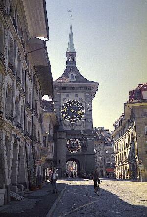
The clock tower in Berne.
19/06/2000 After a restful morning in camp (our feet hurt, from too many Alps!) we walked along the Arne River from the campsite into central BERNE, about 1 hours walk, along a delightful riverside bicycle path / walkway. The swiftly flowing river was full of swimmers as it was 29°C in Berne this day. A charming old city, with most distinctive architecture, small enough not to have serious traffic problems.
Route map Berne - Luzern - Susten Pass [54Kb]
20/06/2000 We drove to LUZERN, perhaps a little larger than Berne, the city has a very pleasant lake side setting. The drive is pleasant but not remarkable, the roads fair, but narrow, and as is the case over most of Switzerland with a great lack of parking places and no obvious SONPS.
The only camping ground (27.20SF for two & camper) was so appalling that we decided not to stay. Camper vans were jammed in like a supermarket car park, with scarcely room to open the doors, let alone extend the annex. The contrast with the nice park in Berne was striking.
As there was not a lot of specific interest to us in Luzern, and we were
not prepared to pay to stay in such unattractive conditions, we decided not
to stay in Luzern at all, and drove south to the SUSTEN PASS where
we stopped, above 2000M elevation, overlooking the huge STEINLIMMI GLACIER.
A small parking area off the end of a hairpin bend provided a SONPS with magnificent
views over the glacier and the Alps, to watch the sunset. ![]() (Photo
above)
(Photo
above)
We were above the snow line, surrounded by isolated drifts of melting snow, which were rapidly receding as there had been a week of 30°C heat in the Swiss cities. Here, with only the campervan, we were closer to the spectacular scenery of mountains over 3000M than in the more touristy Interlarken-Jungfrau area. Motorcycles tour this road in their hundreds each day, but it is very quiet at night, with scarcely any passing traffic after sundown.
This is the real Switzerland, as close as it gets to being unspoilt, and its free! Far below across the valley, we could see, through binoculars, several campervans that had also found an excellent SONPS in the parking area at the foot of the glacier, which is reached by a short but steep (1st gear in the Transit Van) road leading off the main road near the small and isolated STEINLIMMI Hotel. The road would be closed in winter by a boom gate, but in summer it is open for all.
21/06/2000 We drove down to the Steinlimi Hotel and along the short steep road to the parking area from where you can walk to the foot of the glacier. Many locals walk up the steep snow covered slopes and ski down in the valleys beside the glacier. There is an alpine hut restaurant about 2 hours 30 minutes walk (Swiss Mountain Goat Time!) on the peak above the glacier. With basic meals served at what are very reasonable prices for Switzerland, SF8.50 for "Soup, wurst and brot", coffee for SF3.00 Beer SF4.00, and they have to carry it all up by helicopter. We didn't walk up, my leg muscles are still on strike after the last few days in the Alps, but the views would be glorious from around 2,900 Meters, and its about the cheapest restaurant in Switzerland.
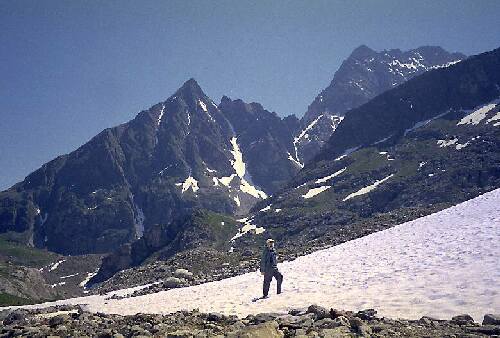
David on the snow field near the foot of the Steinlimmi
Glacier. The car park is an excellent SONPS.
The STEINLIMMI GLACIER (Altitude 2093M) car park is one of the best
SONPS in the Alps, and locals were camped there, awnings extended, tables
and chairs out, the works, and no one was bothered. However it is purely a
summer SONPS, the entire SUSTEN PASS is closed in winter from December to
June. After spending the morning on a short hike up to the glacier and
soaking up the wonderful scenery, we proceeded on through the Susten Pass
via WASSEN and ANDERMATT to the OBERAL PASS (2044M) Although
spectacular at first when leaving Andermatt, the Oberal Pass lacks the scenic
grandeur of the Susten/Furka passes.
Route map Susten Pass - Oberal Pass - Chur - St Morits - Italian border [58 Kb]
There are no SONPS until reaching the top of the Oberal Pass, but on the decent toward SEDRUN there are a number of SONPS off the ends of hairpin bends, where you can get well off the road in small level areas. They are not paved but obviously used for parking for rest breaks, viewing the scenery and parking to hike the countryside. We parked overnight in one, spending a quiet night, as traffic is very light after sundown
22/06/2000 Along the road from SEDRUN to DISENTIS MUNSTER and along the RHEIN RIVER toward ILANZ there are a number of pleasant parking areas, some suitable as SONPS.
We proceeded through CHUR and south towards ST MORITZ
. CANTON TILSIN is very campervan unfriendly with
lots of no campervan signs posted at almost every stopping place.
St Moritz has a pleasant setting on a lake, but it is just another overpriced
tourist resort town, and after an hour or so of exploring we proceeded on
to MALOJA heading for the Italian border. Here in a small village there
are several small souvenir shops where you can pick up any last minute Swiss
items, at prices better than in St Moritz. The route via the MALOJA PASS
(1815M) is pleasant and scenic, and we soon crossed into Italy, with no formality
at the unmanned border crossing.